Thursday, June 21, 2012

Arches, Arches and more Arches

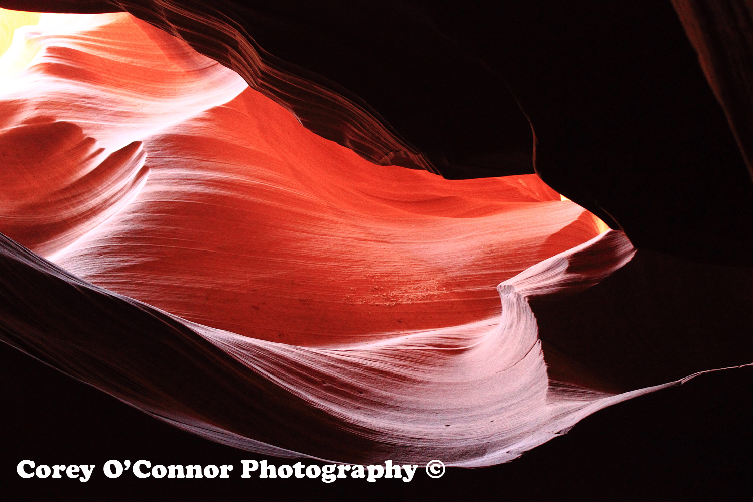
If one thing is for sure, there is a shit load of arches in Utah. I don't technically know how many arches it takes to make a shit load, but I do know that Utah would definitely meet that criteria. In Arches Natural Park alone there are over 2000 natural stone arches, not to mention countless more throughout red rock country in Utah and the West at large. There was too much to see on this trip to spend much time visiting arches, and as we came to learn, if you've seen a few arches, you've seen them all. I don't say this to downgrade the awesomeness that is an arch of rock sculpted over the ages to form a natural bridge, I say it because after seeing a few you start to get desensitized to it. So on this trip we decided on three short hikes to three very different arches that I felt encompassed everything they had to offer. First we would hike to Delicate Arch in Arches National Park, Utah's poster child, portrayed on their license plate and just about anything else that is advertising Utah. Second a hike to Corona Arch, just outside of Canyonlands, made famous recently on YouTube by claiming to be the world's largest rope swing. If your interested, and you should be, watch the video here. And finally, Mesa Arch, located in Canyonlands National Park's Island in the Sky District. All three offered something different and unique, and since each one had to be hiked to, it gave me a great opportunity to work on the blisters that had been forming by this point in the trip.
So our first stop on the Arches tour took us to Delicate Arch which was our one and only hike in Arches National Park, also know for being Canyonlands bigger, more popular older brother. The hike itself was three miles round trip over open exposed slick rock, and since it was quite windy that day (gusts up to 55mph) there was plenty of dust and debris flying around. This was also the most crowded hike as everyone and their brother is likely to do this hike if they are in the area due to it's iconic image. After getting to the arch the wind was almost unbearable and we watched countless people (Including Nicole) lose their sunglasses and hats off the side of the mountain. So after waiting in line to snap a pic in front of the arch, which was pretty incredible looking I might add, we headed back the way we came down the trail to the cars. On the way back someone had opened shop with all the hats and sunglasses he had scavenged at the bottom. All and all a must do hike, nothing to spectacular, but if you go on the right day I'm sure there isn't too bad of a crowd and the arch is worth seeing.
The second hike was to Corona Arch, and like Delicate Arch, it was a 3 mile round trip hike. The trailhead for this hike was on the bank of the Colorado River, the architect for a lot of the Canyons in the West, Including the Grand Canyon. There was some sort of Hippy tent convention going on that I wanted to be a part of, but forced myself to set out on the trail anyways. Much fewer people on this hike (maybe 6-7 total) and as we approached the Arch we could see incredibly that there was a group of people that had actually set up and were doing the rope swing. This was a complete surprise to me because I just assumed it had been a one time thing for that video, and now I was seeing it live in front of me. So after we hiked up to the arch we talked with the dudes that set up the rope swing and watched one of them do it. It was 10 times more bad ass to see it in person and I wished that I could have somehow convinced them to let me try it. They told us that for a test run they filled a backpack up with rocks and rigged it to the rope and threw it off. After the rope failed and the backpack came plummeting down, they promptly flipped a coin to see who would try it first. What? Yeah. So I gave the guy who I watched rope swing my contact info so he could snag the pictures from me then we headed back to the car, stopping only to take a classic girl-tied-to-the-train-tracks-by-evil-villain picture, which of course is a staple of any trip to the wild west.
And finally on our last day in Moab did the sort hike out to see Mesa Arch, which is on the edge of a Mesa, creating a natural frame of the Canyonlands below. Most people who visit Canyonlands make the 0.5 mile trek out to the arch and snap a picture, many of which do so at sunrise. We on the other hand did not, and since we maaay or may not have drank to much and spoke like British Royalty the night before, saw it quite a bit closer to sunset than sunrise. Not much to write about hike-wise since it was so short, but the views at the Mesa were extraordinary, made even better by the fact that there was a pretty sweet arch over the cliff. So we took our pictures on the arch and headed back to the car. Utah has an incredible amount of must see landmarks and countless miles of wild space to explore, and if you do make your way out there, make sure you devote at least some time to seeing a few of the arches it has to offer.

Mileage: 6.5 Miles

Island in the Sky.

Delicate Arch.

Crazy Man.

Corona Arch.

Obstacles.

Dastardly McNasty.

Mesa Arch.

Grand View Point.

Monday, June 18, 2012

Chesler Park

Canyonlands National Park was established in 1964 and currently encompasses 527 square miles. To be honest I didn't really know much about Canyonlands before last year, I had wanted to go to Utah for a wile but mostly to visit Zion and road trip that section of the West. It wasn't until I watched "127 hours" that I was introduced to Canyonlands, and immediately wanted to go there. If anyone has seen the movie your first thought is probably, why the hell would you want to go there after seeing a movie about someone cutting off their own arm, well yeah that part sucked but the setting of the arm peacing fiasco was completely bad ass. So as fate would have it a little less than a year later I would be hiking in the same vicinity as Aron Ralston did when he got his arm stuck under a boulder that fateful day in April of 2003.
 The Chesler Park hike was the flagship hike of our trip to Utah and it was chosen especially to encompass all aspects of what one would come to Canyonlands NP to see. It had strange rock formations, colorful spires, a desert meadow, a slot canyon, and numerous other sights that marked the 11.5 mile round trip hike. Chesler Park is located deep in the Needles District of Canyonlands NP and requires a 30 something mile drive to the entrance and an additional 10+ miles (mostly on dirt roads) to the trail head. We began hiking around 10 am after camping out the night before at the Bureau of Land Management's Hamburger Rock camping area. After a windy night without much sleep we were eager to pack up our things and start out on the trail. The first half mile was pretty much strait uphill and I could feel the death stares of my friends behind me, no doubt plotting to kill me if the next 11 miles were similar. But as luck would have it the trail leveled off and headed into some great scenery as we made our way to the entrance of Chesler Park. After a few miles of heading through winding canyons and slipping through thin cracks in the spire walls that surrounded us we finally made our way into Chesler Park, a large meadow caged in from the surrounding slick-rock desert by large colorful spires. This section of the hike meandered through low scrub brush and over dried up riverbeds until we got to the end of the park and dropped down into Devil's pocket. After hiking for a bit we met up with a 4x4 Jeep road and followed that for about a mile to the entrance of the Joint Trail where we stopped and ate lunch. After fighting off the urge to nap and watching ravens fly off with a years supply of free bagels courtesy of Nancy, we headed up to the Joint Trail, a 0.5 mile section of slot canyon that passes through a crack in the rock. Slot canyons are very narrow, often only a few feet wide, and this one was probably no more than a foot and a half wide at it's tightest section. This part of the trail was other worldly and would not have been a great place for someone with even the slightest bit of claustrophobia, memories of "127 Hours" came to mind and I hoped Mark wouldn't have to cut off his own arm, mostly because I would never get him to come on another trip again. There was a large cave type structure at the beginning of the Joint trail that was full of 100's of Cairns made by other people who had passed through previously. After getting lost, and exploring the side canyons for about an hour we made our way out of the slot canyon and back into Chesler Park. It was at this point I'm pretty sure the mirages of comfy beds and cheeseburgers, or in Mark's case visions of my funeral, started to appear and each additional mile felt longer than the last. Don't get me wrong the scenery was great and I was stopping just as frequently to snap pictures of the newest landmark I thought was the coolest thing I had ever seen, but 11.5 miles is a long god damn hike. So after going through the first 6 stages of grief we finally accepted that the hike would be over soon and we hoped the fuggen car started and the air conditioner worked when we got there. We finally got back to the car sometime around 5:30, high fived, and headed into Moab to check into our sweet, sweet hotel for the night. I can honestly say, this was one of the most fulfilling and awesome hikes I have ever been on in my life and only added to my want to move out West and be able to do stuff like this all the time. Canyonlands is beautiful and unlike anything I have ever seen before, and I can't wait to let my boots loose in there again. Once again thanks to all two of you who read this, I appreciate your support and thank you for reading my ramblings.

Mileage: 11.5 Miles

Like a Lizzzard.

Hiking!

Spires.

Chesler Park trail.

Joint Trail.

Ancient Indian Writings on the way to the hike.

Slot Canyon.

Twisted Tree.

Cairn Cave.

Chesler Park.

Cairns.

Colors.

The Needles.

Tuesday, June 12, 2012

Antelope Canyon

You might not know this but Indians, excuse me, Native Americans do have more than just Casinos. Seriously, in fact the Navajos have a Reservation the size of West Virginia covering parts of Utah, Arizona, Colorado, and New Mexico. And on this land is one bad ass canyon shaped by flash floods which is the setting for my next hike.
So I'll state up front that this wasn't much of a hike but more of a short walk through an amazing looking canyon. Since this was on Navajo Land, you had to have an Indian guide to be able to go through the canyon. On a side note the only prerequisite to being an Indian guide is to be part Indian and have a truck from the 80's Jerry rigged with a bench in the back, oh and you also have to drive that truck through the desert like your illegally smuggling immigrants over the boarder. We fortunately found one such Indian qualified to perform the task, and since she was so generous only charged us $45 to see it, but we did get a free authentic Indian dance in a Taco Bell parking lot. It's fine though, I'm sure all the meat they used there was spear caught.
So after a long ride out into the desert we finally got to Upper Antelope Canyon, along with 10-15 other tour groups, and headed in to see what all the fuss was about. That place was pretty amazing and instead of babbling on about it, I'm gonna let the pictures do the talking. Definitely a must do if you're ever planning a trip to the area. Tours run out of Page, Arizona, and we used this one here.

Mileage: About 0.5 Miles

Antelope Canyon.

More Antelope Canyon.

Can't stop.

America!

Sand Waterfall.

Stone Wave.

Opening to Hell.

Little cammo guy.


Sunlight.

Crazyness.
Our Chariots await.

Monday, June 4, 2012

B-E-A-UTAH!

So as you may or may not know, I just went on a trip with some friends to Utah to explore a few National Parks and hike in some of the best places in the United States. I got back a little over a week ago and I have to say I'm having the worst vacation withdrawals ever....everything about the trip was awesome, from the sights, to the hikes (fuggen phenomenal), to the food, to getting to spend time with great people. It feels as though something is missing now, like that trip was home and being back here is foreign to me. It's an odd feeling but I guess it stands as proof that it truly was a great trip.
But enough with the deep meaning stuff and on to the hiking. It. Was. Fucken. Awesome. Every part of it, from the first steps when I was convinced that a rattle snake was under every rock and a cougar was going to throw me off of a cliff Lion King style, to the very end when I felt like I had been roaming in the desert for ever and every little canyon or rock formation was still as bad ass to me as the first one I had ever seen. We did a lot on this trip, and I mean a lot. My delusions that we could see and do everything actually became reality, and it never (OK maybe once) felt like it was too much. The hiking here was great and while I can babble on about the whole trip like a kid that just got back from Summer Camp, scratch that, Space Camp, I'm going to have to break up the experience into each hike and save some of the stories for later.
The first hike that we went on was in Zion National Park, named by the Mormons blah blah blah, but honestly a completely incredible place. It is like Yosemite in the desert; the main portion of the park is in Zion Canyon and is surrounded by huge Navajo sandstone cliffs shaped by the Virgin River, which flows through it. There is plenty of spectacular hiking here, and because we only had two full days to spend it was hard to choose which hikes to go on. For out first hike we choose the Zion Narrows, which follows the path of the Virgin River upstream through a quite narrow canyon, meaning as wide as the river with huge walls of stone on either side hundreds of feet high. In some places its no more that 20 feet wide, and even further upstream it can get to less than a few feet causing you to have to squeeze your way through.
The hike starts at the last stop on the parks bus system, a inconvenient but environmentally necessary tram system that is the only means of transportation allowed in the park, save for the rich people that can afford to stay at the Zion lodge (prob all from Connecticut). The first section starts at the Temple of Sinawava using the Riverside Walk Trail which hugs the river for about a mile before you get to the entrance of the narrows. From here on out it is all hiking in the river which was pretty challenging but completely unlike any hiking I'd ever done before. You need to rock your boots even thought they are going to get soaked and use a hiking pole (thanks Mike) for balance. The scenery was awesome, there were a few short waterfalls flowing down the sandstone cliffs and in some sections the sun lit up the canyon walls to a glowing orange color. Every section of the hike I had to contain myself not to stop and take my camera out of the dry bag and take a million pictures of literally everything. Once we had enough of walking in water we stopped for a snack and headed back the way we came, since being a narrow crack in the rocks that's the only option. On our way back we saw a couple people repelling into the Narrows via the waterfall we had previously passed by and there was a number of people that found deeper areas of water to cliff jump into. It's worth noting that the farther you hike in, the less people there is, by about .25 miles in anyone rocking flip flops or wearing babies as a scarf had already turned around. We got out of the river and headed the final mile back to the buses soaking wet and pumped as shit. Such a good hike, easily ranked in my top three of all time. If you are ever even anywhere near this National Park, just go, seriously go....and do this hike, I'll even go back and do it with you... just buy my plane ticket. There is Waaaaay more to come folks, so stay tuned. And for those of you who only come here for the pictures, well here you go:

Mileage: About 6 miles.

Orange Glow.

River Hiking.

Beasts.

Chomping Deer.

The Route back.
Colorful Water.

Waterfall.

Hikers.